Village Shopping in 1945
To accompany my collection of village photographs, I have
drawn maps of Barrow for several different periods of the
1900s to correspond with the considerable growth of the village
in the 20th century.
However, to use an 'in phrase', the 20th was a century of
two halves. During most of the first half, the map was practically
unchanged. Certainly, new houses were built (including the
council houses on Grove Lane, Sileby Road and River View)
but with the exception of River View, no other new streets
or roads had been made since Warner Street and New Street
were built in the early 1900s. In the second half of the 20th
century, there was of course a seemingly unending expansion
of the village - starting with the Brook Lane development
just after World War II finished in 1945. This year represented
an important turning point in the development of Barrow. Also,
at that time, there were probably more shops and businesses
etc than at any other time in our history.
I offer this 1945 map to place on record where all the commercial
and service establishments were located at this important
time. Apart from some 'fine tuning' assistance from Mrs E
Pagett, the map had been drawn from memory. Thus I hope that
any errors or omissions will be excused.
From time to time, reminiscences about the village appear
in Barrow Voice and any further elaboration here would be
superfluous. However, I must add that the number of shops
is amazing - especially when one considers that WWII had just
ended. Strict rationing of most food, clothes and fuel had
been in force for nearly six years and yet, the village managed
to support four bakeries, four family butchers, a pork butcher
and ten grocery or general provisions shops. Although the
sweet ration was only 3/4 lb per month, there were three confectioners
despite the fact that the grocers also sold sweets.
There were three coal merchants in the village and also,Tom
Draper of Sileby delivered coal here. Even in those days when
the population was less than half that at present and very
few people had a cheque book, there were two banks in the
High Street opening two mornings a week. Other financial institutions
were the Co-op which operated a Penny Bank and the Barrow
Building Society. It had an office in Granby Street, Loughborough
but was open for business on one Monday evening per month
in the school room of the Wesleyan Chapel.
With so many facilities available and prices strictly controlled,
one wonders why visits to Loughborough were so popular. Perhaps
it was the cheap fare - 4d for adults on Howletts,Trent or
Midland Red buses or the attraction of the three cinemas and
the Theatre Royal. But then in the 1940s, we had our own dance
hall, film shows and our own repertory company, 'The Jesters'
but that is for another time!
Kevon Thompson
The Old King Bill
One of Barrow's many 'lost' pubs, the King William IV Beer
House was situated on the corner of High St. and Church St.,
opposite the Three Crowns. It is now a private house owned
by Jim and Joy Greig. During recent building works, they invited
me to take a look at the remaining evidence of its life as
a pub.
King William IV reigned from 1830 to 1837 and was Queen Victoria's
uncle. He served at sea from the age of 14 until he was 25
when he was made Duke of Clarence. For the next 20 years he
lived with an Irish actress called Dorothea Jordan, siring
10 children. He then unexpectedly became next in line for
the throne, and had to marry to produce an heir (and to find
someone with money to pay off his debts). Unfortunately, his
marriage to Adelaide of Saxe-Coburg produced only two daughters
who died in infancy. Many pubs were named after this colourful
character, including ours which opened in about 1840.
It is surprisingly difficult to trace the history of pubs
and landlords in public records, particularly when they were
only Beer Houses rather than fully licensed Inns. However
we do know that the King Bill was run by Mary Perkins in 1896,
probably by her husband Alfred in 1891, and by Arnold Squires
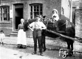
in 1936. The public area consisted of 2 rooms: the Bar, accessed
by the front door (fig. 1) which is now bricked up, and the
Snug, which was separated from the Bar by a wood and glass
partition. Beer was brought up from the cellar in jugs and
served at the bar counter. This route to the cellar is now
blocked off, but can still be identified. The thralls, on
which the barrels stood, are still in the cellar (fig.2).
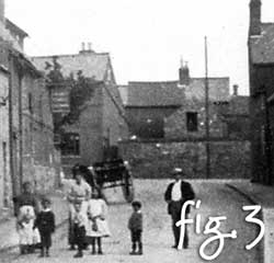
To the right of the house was a skittle alley, visible in
the photo taken from Cotes Rd.(fig. 3), which occupied the
site of old stone cottages whose doors and windows can still
be seen in the wall between the King Bill and the Alliance
and Leicester. A fireplace remains on the back of this wall.
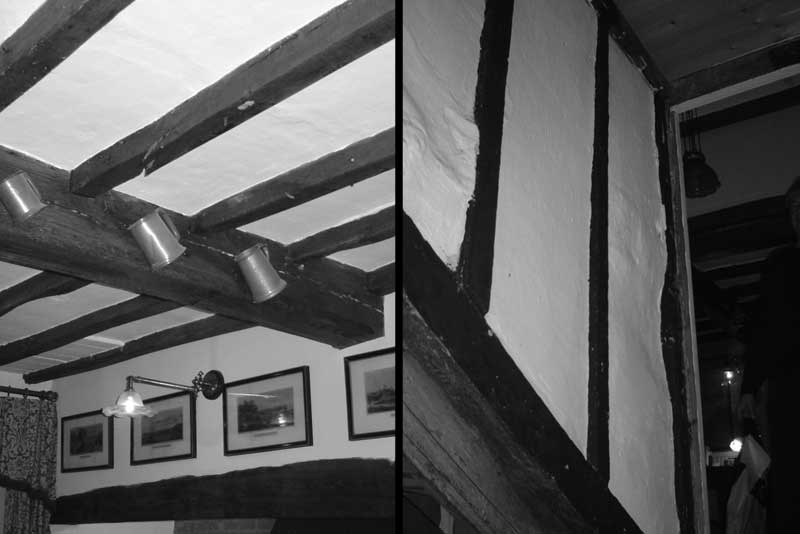
As with many older houses in the village, its construction
is a bit of a hotchpotch. The garden wall may well be medieval;
the cellar and parts of the lower walls are stone; there is
evidence of timber frame and cob (mud and straw) (fig.4);
much of the house is oak beamed, usually reused from ships
or other buildings (fig.5).
It seems possible that its origins lie as far back as the
1600s, and parts certainly date from the mid 1700s. Unfortunately
the deeds are incomplete and unhelpful.
Joy Greig (nee Lewin) has a photograph of herself in the
garden, aged about 11 - strange that she should come to live
there so many years later. She tells a tale that her mother
was sent to the King William IV by her grandmother with a
jug to buy some beer. However, she was underage and someone
snitched, for a police constable was waiting for her when
she arrived! Jim has an intriguing invitation card, dating
from the early 1900s (fig.7).
The pub finally closed its doors for business in 1942, but
during the second world war it was home to evacuees from Ipswich.
Norman Riley remembers playing with them in the skittle alley,
and when it got dark they would be fetched out by Margaret
Horton carrying a lantern. One night, however, the windows
were lit up not by the lantern but by the crash of a Dakota
aeroplane near the railway in which four Canadian airmen were
killed. According to Ken Quail, on VE Day the owner threw
all the beds and bedding out of the window into the street
and set fire to them. More evacuees from London lived in the
cottages by the Three Crowns, who apparently returned later
with gifts of jellied eels which, says Norman, were horrible'
As a Londoner by birth, I could not possibly comment (ugh).
There are two photographs of the building in the Community
Centre lounge that are worth a look, as are the other pictures
therein.
Jim and Joy would like to thank everyone who has commented
so favourably on the recent facelift to their home, carried
out by Ken, and I, in turn, thank them and Norman for sharing
all this information. As usual, any errors are mine alone.
FOOTNOTE - You may remember the search for Bucknall Hill,
which we decided was also known as Tom Sheppard's Hill and
Barrow Hill on the Nottingham Road. I recently found out that
John Bucknall was granted an allotment in 1761 under the Enclosures
Act at the top of the very same hill - problem solved.
Extra information, pictures, ideas and comments gratefully
received at keith.chaplin@tiscali.co.uk
or phone me on 01509 412196.
|


