
Recent flooding brought about numerous comments on local social media from residents who were querying the traffic light use, the single lane etc. on Bridge Street’s Heritage Listed Grade 11 bridge.
Some residents in the village may be unaware why, 30 years ago, the decision was taken by the County Council’s Highways to change the status of the highway over the river bridge.
The aim was to secure the safety of pedestrians and try to protect the listed structure and make the road safer for all users. Ultimately the decision was to make the bridge single lane with traffic lights control and to widen the pavement on the side with access to Quorn. There was anecdotal evidence that pedestrians were in danger from traffic, particularly students travelling between schools. As a Grade 11 Listed Structure (built 1845), the bridge is unable to have a pedestrian footbridge attached to the side (suggested by some) since this would affect the facade of the structure and be unacceptable to Historic England.
Information given to us by Leicestershire County Council stated: A full structural assessment was undertaken in December 2015. The assessment results proved the bridge was capable of carrying a maximum 40/44 Tonnes Allowable Axle Loads which means that the bridge can accommodate ‘normal’ vehicle loading including HGVs, fire engines, etc. totalling 40 tonnes. The bridge had extensive brickwork repairs undertaken in November 2020 so its condition remains good. The leaning parapets have been identified and are being monitored.
In 1988, when we took part in the public enquiry to the plan for the Quorn, Mountsorrel, Rothley A6 bypass, we expressed our concern on the impact this would have on this village. We were told that the bypass would cause a small increase in traffic, and no impact on river Soar flooding. Since that time there has been significant housebuilding with no uplift in the road system in this and nearby villages to cope with increased demand and climate change has affected flooding.
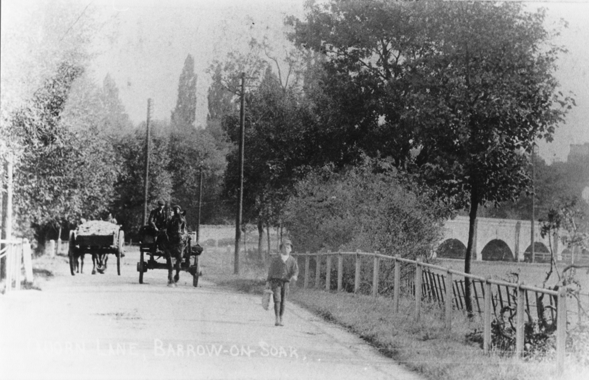
The flooding of Slash Lane and Mountsorrel Lane closes access to the A6 at Mountsorrel and flooding at Cossington/ Rothley closes the access to the A6 southbound and northbound via the ‘old’ A6 equally affecting those needing a cross-valley route. This causes increased use of the river crossing at Bridge Street. Traffic backs up on Sileby Road and High Street/ North Street towards Nottingham Road as well as queuing from Quorn. There is a significant economic and environmental cost for this from the loss of time and use of fuel so it is not surprising there are demands to improve traffic flow on Bridge Street by removing the traffic light control. The bridge was built when heavy traffic was horse and cart. See accompanying photo. Possible mitigations may include:
As a result of the cancellation of HS2 beyond Birmingham, Leicestershire County Council, our highway authority, will receive a share of funding released. This will be £232 million for this county. We need to ensure our area receives a share to fund much needed highway improvements.
Joyce Noon & Alan Willcocks